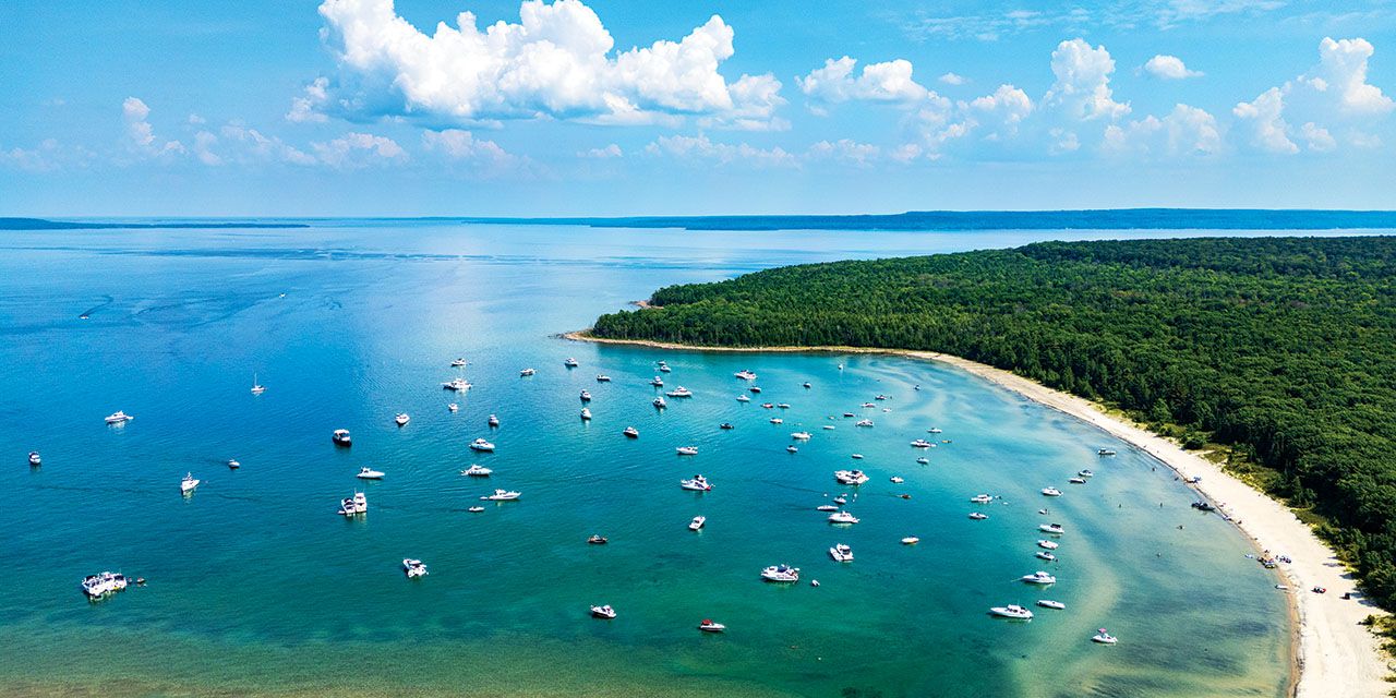
Reaching Beckwith Island requires planning, skill and good weather—but the reward is one of Georgian Bay’s most spectacular shorelines.
Places You Earn
By Cara Williams | Photography by Clay Dolan
Sweat, dust, river miles, roots, climbs and open water—these are the Escarpment experiences where the hard part is getting there, and the payoff is the whole point.
There are easier ways to spend a summer day. You could drive straight to the lookout. Park beside the beach. Scroll through photos of remote beaches instead of sweating your way toward one. But the best places around the Escarpment rarely give themselves up that easily. They ask for something first. A climb. A headwind. A few hours on the water. Loose gravel. Relentless sun.
Maybe that’s why these places stay with us longer. Not because they’re hidden or out of the way, but because they asked something of us first. A little effort sharpens everything that follows. The view runs bigger. The swim bites colder. The Creemore Lager, somehow, tastes better. And by the time you arrive, you’re already part of the story.
These are the places that are better because of what it takes to reach them.
Boat Run | Beckwith Island
EARN IT Wind, waves and open-water exposure
REWARD Clear turquoise water and some of Georgian Bay’s most pristine beaches
Reaching Beckwith Island is not casual boating. From Collingwood Harbour, it is a long run across Nottawasaga Bay—roughly 25 to 30 nautical miles of open water that demands planning, experience and careful attention to conditions. A calm morning can shift quickly depending on wind direction, and weather systems can build fast across exposed water.
Experienced boaters navigating their own vessels need to respect the shallow sections northwest of Collingwood, the long stretches of bay with little shelter, and the reality that turning back is sometimes the smartest decision.
That unpredictability is exactly what makes a safe arrival feel so satisfying.
The island is part of Beausoleil First Nation territory, home to the People of G’Chimnissing, whose lands include Christian, Beckwith and Hope Islands. Visitors should understand that this is not simply an open public beach. Access is managed by the Beausoleil First Nation, day-use mooring and camping fees apply, and current permissions, rates and visitor requirements should be checked before heading over.
That respect is part of the experience. White sand shoreline. Clear, turquoise water. The silence after shutting down the engine feels almost complete.
Some places, like the coves and beaches of Beckwith Island, feel better precisely because they are not effortless to reach.
KNOW BEFORE YOU GO
• Distance: ~25–30 nautical miles from Collingwood
• Skill Level: Intermediate to advanced boating experience and GPS highly recommended
• Watch For: Rapidly changing weather
• Respect: Beckwith Island is Beausoleil First Nation territory; check current access, fees and visitor requirements before going at chimnissing.ca
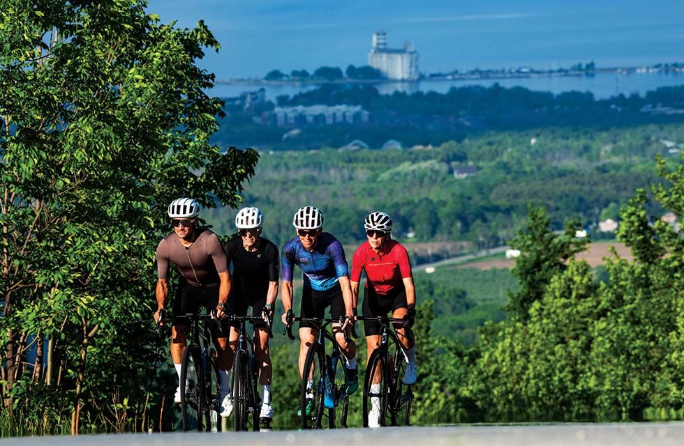
Cyclists grind their way up Scenic Caves Road, one of Ontario’s best-known Category 3 climbs.
Road Ride | Scenic Caves Road
EARN IT A relentless gradient and burning legs
REWARD One of the best views over Georgian Bay
Every cyclist in the region knows this climb. At 2.3 kilometres long, Scenic Caves Road has become a local rite of passage and one of Ontario’s best-known Category 3 climbs. The average gradient sits around 9 per cent, but that figure is misleading. Several sections push well into the double digits, with the steepest pitches reaching a leg-aching 20 per cent.
It starts almost the instant riders pass the ski lifts at the base—never an encouraging sight when already clipped in. The opening stretch is manageable. Riders settle into a rhythm under the tree cover, gears still in reserve. Then the road keeps tilting upward, and its real character starts to show.
Then comes the switchback. This is where Scenic Caves stops feeling scenic and starts feeling personal.
The grade climbs above 15 per cent and stays there. Riders begin to weave a little across the shoulder—not for lack of skill, but because the pitch is, frankly, unreasonably steep. Conversation stops. On a busy summer weekend, it’s common to see riders stalled at the roadside, folded over their bars, draining a water bottle and quietly reconsidering their life choices.
The suffering is half the point. Scenic Caves rewards stubbornness more than raw fitness; the road simply asks the same question over and over: will the pedals keep turning? And then it lets go.
Near the top, the grade eases and riders drift, almost without deciding to, toward the guardrail above Georgian Bay. Out come the phones. Breathing settles while Collingwood, the bay, and the patchwork of farmland below run out to the horizon.
Nobody skips the photo.
KNOW BEFORE YOU GO
• Distance: ~2.3 km
• Elevation Gain: ~200–210 m
• Gradient: 9–20%
• Best Time: Early morning or cooler evenings
• Bring: Water and humility
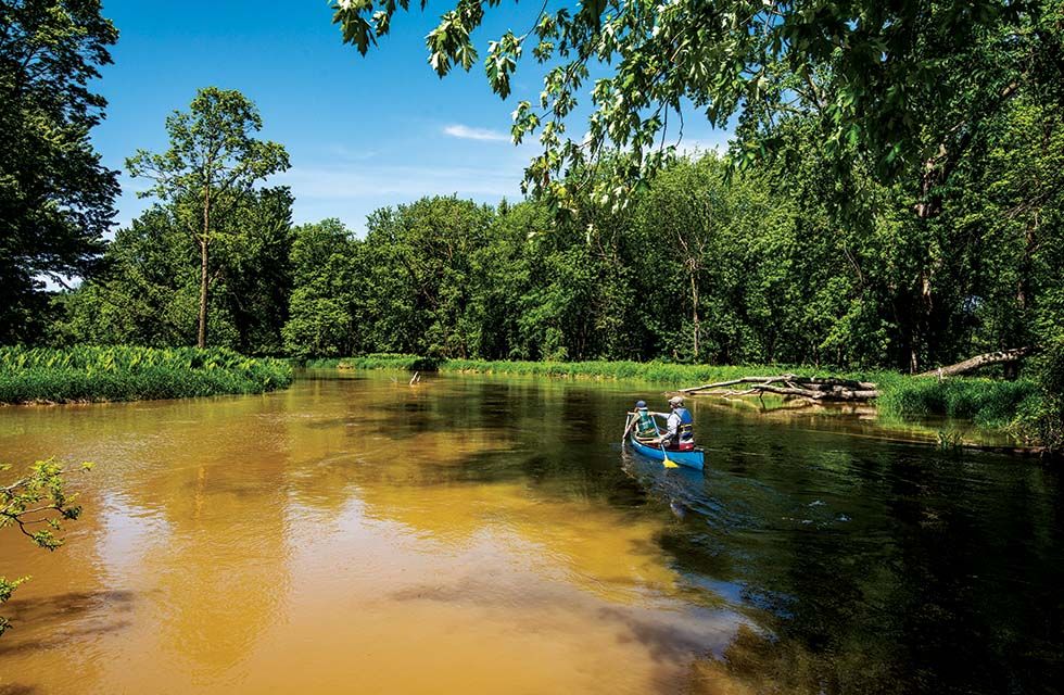
The Nottawasaga River winds toward Wasaga Beach, where paddlers arrive at the world’s longest freshwater beach.
Paddle | Edenvale to Wasaga Beach
EARN IT River miles, muddy launches and changing currents
REWARD Arriving onto the world’s longest freshwater beach under your own power
Launching from Edenvale Conservation Area, the paddle down the Nottawasaga River begins quietly—overhanging trees, banks that look much as they always have, the current doing most of the early work.
It’s about 13.5 kilometres downstream to Wasaga Beach Sports Park or Schoonertown, slow and calm enough to suit canoeists, kayakers and stand-up paddleboarders alike. Slow, though, isn’t the same as simple. Water levels rise and fall through the season, muddy banks turn every launch and landing into a small negotiation, and depending on conditions, little swifts can form near Jack’s Lake.
About halfway down, the river widens. The Edenvale Moraine softens into sandy shoreline and low dunes. By midsummer, dragonflies hover low over the water, mosquitoes rise in the still pockets, and the quieter shaded stretches can turn buggy enough to make stopping feel like a mistake. That last stretch toward Wasaga can drag on and on if the wind swings around against the current.
Then, sand. Coming off three or four hours of river and pulling straight onto the beach has a strange, cinematic charge to it. Shoulders ache. Hands are raw. Someone always goes shin-deep in the mud climbing out of the boat. And there it is, the moment you hit land: the world’s longest freshwater beach, opening up right in front of the bow.
Arriving by car never feels like this.
KNOW BEFORE YOU GO
• Distance: ~13.5 km
• Time: 3–4 hours
• Conditions: Natural, wilderness waterway with changing currents, fallen debris and potential logjams
• Watch For: Deep mud along the riverbanks if exiting your craft
• Bring: Appropriate safety gear and bug repellent
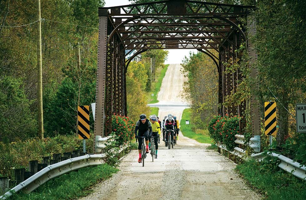
Concession roads, rolling hills and endless route options make the Beaver Valley a premier gravel-riding destination.
Gravel Ride | Beaver Valley Loop
EARN IT Long climbs, loose gravel, heat and dust
REWARD Valley views, fast descents and a butter tart somewhere near halfway
The best gravel rides have a half-improvised quality, and the Beaver Valley Loop is best approached that way. Rather than one prescribed route, think of it as a choose-your-ownadventure ride: orchard roads out of Clarksburg, quiet gravel concessions, paved valley descents, exposed ridge-line rollers and, if your legs are asking for trouble, one or two very memorable climbs.
Leaving Thornbury, Bruce Street to Clark Street/Side Road 30 is a natural way to leave town and slip into apple country. The Blue Mountains–Meaford Townline can serve as a rural spine toward the valley, while a network of concession roads and quiet paved descents eventually leads riders into Kimberley.
For a softer, scenic approach, riders can build a loop along Old Mail Road through Fairmount before dropping into Epping and the Beaver Valley, where Epping Lookout offers one of the region’s most dramatic panoramic views.
Then Kimberley appears like an oasis. Bikes lean against fences outside the Kimberley General Store while riders reach for cold drinks, butter tarts, sandwiches—whatever sugar is closest to the till. Some drift over to Hearts Tavern, delaying the inevitable truth that there are still kilometres left to ride.
Those looking to make the ride bite back can work Sideroad 7A into the route. Known by local gravel riders as The Crucible, it is steep, loose and memorable—the kind of climb that turns a scenic valley ride into something you truly earn. As the definitive wall climb of the Beaver Valley Classic bike race, Sideroad 7A features steep, loose and unmaintained gravel gradients that have become legendary among regional cyclists.
However you piece it together, a Beaver Valley gravel ride rewards adventurousness: a little planning, a little improvisation, and a willingness to take the road that looks interesting.
KNOW BEFORE YOU GO
• Distance: Flexible; build your own loop up to 120 km
• Elevation Gain: Depends on route choice
• Terrain: Gravel, pavement and optional rail trail
• Suggested Tires: 35–40 mm or wider
• Best For: Intermediate to experienced gravel riders
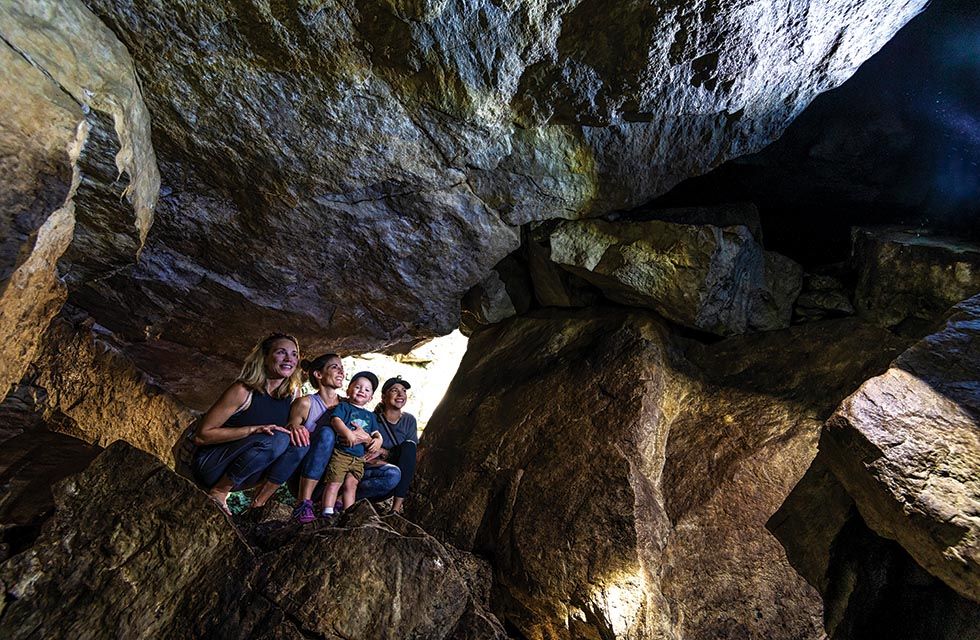
Riders who make it to Metcalfe Rock can explore the limestone caves.
Mountain Bike | Kolapore Uplands
EARN IT Technical singletrack, roots, rock and constant effort
REWARD Deep-forest solitude and the hidden caves at Metcalfe Rock
From the main trailhead on Grey Road 2 near Ravenna, riders vanish almost at once into the Kolapore forest—one of the most rugged and rewarding trail systems in the area. The network is wild, technical and gloriously imperfect: an endless tangle of roots, limestone rock gardens, punchy climbs, greasy corners and narrow singletrack that never lets attention wander.
Half the challenge is simply knowing where the trail is going; heads may give out before legs do. Kolapore is kept deliberately raw, a web of intersecting trails with next to no signage, so a map or GPS route isn’t optional. Riders link sections with names like Paradise Highway, Red Death and Kolapore Church, working slowly north toward Metcalfe Rock along the rim of the Beaver Valley.
The riding is relentless, in exactly the way mountain bikers tend to want it to be—one technical descent handing off to the next awkward scramble up bare Escarpment stone. Then the forest opens. Bikes go down beside the trail and riders carry on by foot into the caves at Metcalfe Rock, turning sideways through narrow crevices, ducking beneath limestone overhangs and feeling their way into cool, hidden chambers, the bright summer day sealed off somewhere overhead.
By the end, everyone is pleasantly wrecked.
KNOW BEFORE YOU GO
• Distance: ~15–25 km
• Difficulty: Intermediate to advanced
• Start: Kolapore Main Trailhead, Grey Road 2
• Bring: Map or GPS route
• Bonus: Bring a headlamp for cave exploration
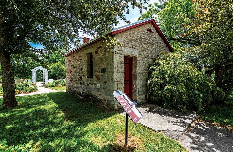
Built in 1892, Creemore’s tiny three-cell jail remains one of the village’s most enduring landmarks.
Hike | Creemore Jail Trail
EARN IT Roots, river crossings and rolling trail miles
REWARD Creemore’s tiny historic jail, followed by a slow wander through town
The reward on this hike is not a lookout or a sandy beach, but something stranger and more specific: a three-cell stone lock-up tucked beside the library in Creemore.
To earn it properly, start at Glencairn Conservation Area and follow the Ganaraska Trail west, for about ninekilometres before dropping into Avening. From there, the final five-kilometre stretch picks up at Carruthers Memorial Conservation Area and tracks closely along the Mad River into Creemore. The full section runs much farther than most day hikers need, but this stretch gives the experience its shape: rolling forest, river crossings, cedar and hardwood, and enough distance underfoot to make the arrival feel deserved.
The trail climbs and drops steadily, never turning punishing, but rarely feeling lazy either. It asks for time more than bravado. Kilometres gather quietly. Boots get dusty. Conversation thins and returns. The river appears and disappears through the trees before the route begins easing back toward town.
Then, after all that forest and trail, the jail appears.
Tucked at 165 Library Street, Creemore’s three-cell lockup was built in 1892 for the exact sum of $425.20—which makes it, by the village’s own cheerful insistence, North America’s Smallest Jail. For half a century, the local constable used it to hold the overnight catch: drunkenness, disturbing the peace, the usual small-town trouble. Anyone facing something more serious was shipped off to the county sheriff in Barrie. Provincial regulations closed it in the 1940s, it reopened in the 1960s as a roadside curiosity, and it has been collecting bemused visitors ever since.
Other towns dispute the title. Creemore, which bills itself as a village with “a big heart and the smallest jail,” does not seem especially bothered.
From there, the rest of town becomes part of the reward. Packs come off. Someone heads for coffee. Someone else finds the bakery. A patio pint at Creemore Springs Brewery rarely feels far behind.
The pleasure here is the contrast: a long walk through river country ending not in wilderness grandeur, but at one of the oddest, most charming little landmarks in the region— with the village waiting just beyond it.
KNOW BEFORE YOU GO
• Distance: ~14 km one way
• Route: Glencairn Conservation Area to Creemore
• Bring: Trail map or navigation app, water, snacks and sturdy footwear
• Note: This is a point-to-point hike, so arrange a shuttle or pick-up in Creemore