Get Your Feet Wet
By Kate MacLennan | Photography by Clay Dolan
Equal parts boardwalk stroll, wetland walk, ridgeline trek, and a trip through time, a hike through the Bognor Marsh is a total surprise and delight.
ON MANY SOUTHERN ONTARIO hikes, the wonders of the natural world are impossible to miss: sweeping valley vistas, waterscapes, waterfalls, and forests so enchanting you think you’ve stumbled into a fairy tale. Hikers are drawn to such trails like moths to a flame, but not so much to the modest marsh, which lies low, reedy, and mucky in comparison. This, hiking friends, is a major oversight.
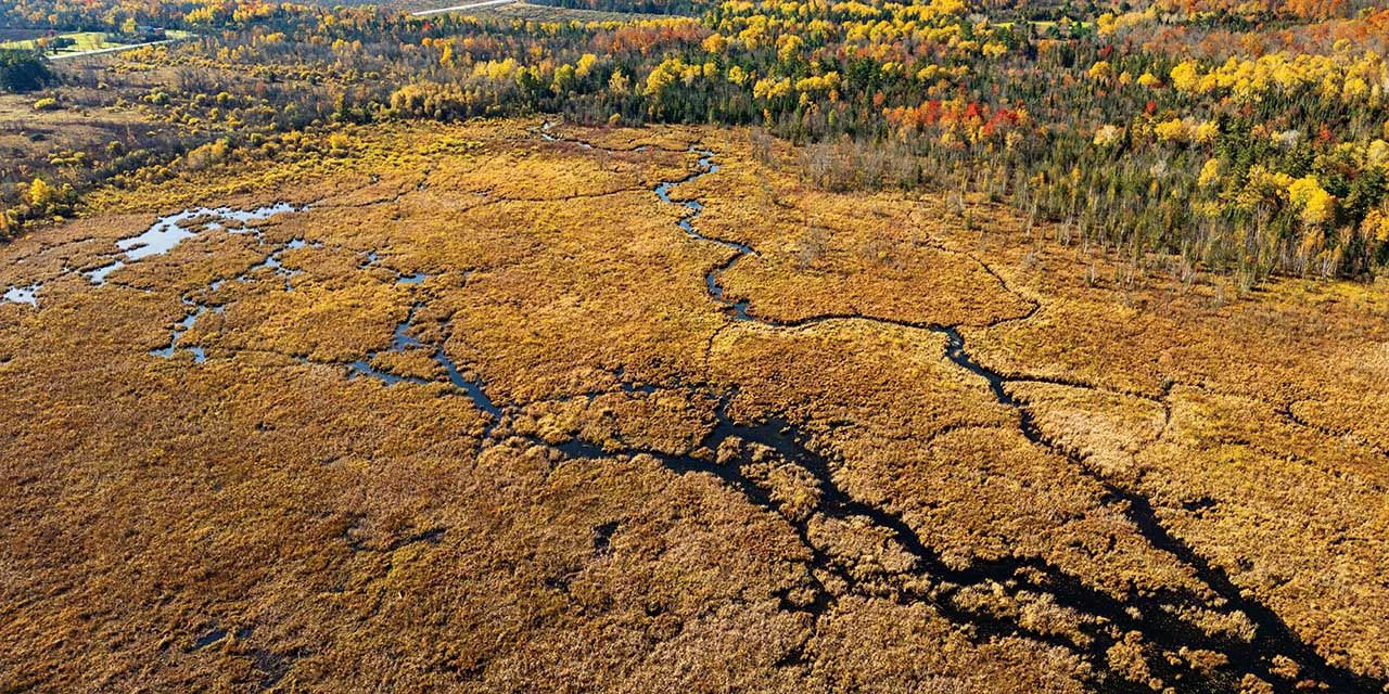
Consider the Bognor Marsh. Arguably not named for marketing appeal, this mineral-rich, shallow wetland makes up for it in hiking and biodiversity. Protected marsh areas like this are treasure troves of genetic variability—home to diverse species and ecosystems, and a window through which to peer at the relationships between them. They’re a snapshot of a story still being written by (or perhaps about) planet Earth: that of life’s miraculous adaptation, survival, and persistence. Seriously, it is—and hikers can access it all via 11.9 kilometres of trail that twists through 668 hectares of one of the largest marsh systems in Grey County.
Like most things we take for granted as part of Earth, this marsh didn’t always exist. The Bognor Marsh was created in 1958 when the Grey Sauble Conservation Authority (GSCA) constructed an earthen dyke and metal culvert control structure to flood 70 acres of land. In the late 1960s, the dyke washed out after being hammered by repeated years of heavy spring run-off and enthusiastic muskrat activity. Ducks Unlimited approached GSCA in 1975 to offer assistance in re-establishing the marsh. A new 700- foot dyke and two-bay concrete spillway were completed in 1977, creating the 100 acres known today as Bognor Marsh.

Rebecca Anthony, Manager of Conservation Lands for GSCA, explains why the area is worth all the trouble. “Conservation is about protecting plants and wildlife, and it’s also about protecting people. Natural areas like Bognor Marsh provide flood protection, help keep water clean, reduce CO2 emissions, and are home to countless species. They also give us places to connect, recharge, and stay healthy—and contribute to a stronger local economy through tourism, recreation, and reduced infrastructure costs. When we care for these places, we’re also investing in our own well-being and the future of our communities,” she says.
Today this multi-use area attracts hikers (including those looking for Bruce Trail access), naturalists, birders, school groups, and hunters (during the fall season). Most hikers start their exploration at the small pay-parking lot just off Grey County Road 18, between Owen Sound and Meaford. (The Grey County Conservation Area annual parking pass works here; otherwise, the cost is $10 + HST per day. Additional roadside parking on 4th Concession North connects directly to a 7-kilometre loop through the marsh.)
From the parking lot, you’ll strike out along a short, treed access road before arriving at the well-maintained floating boardwalk that winds unobtrusively through the marsh. Along the boardwalk are signs to educate visitors about the area’s ecology and wildlife. Many, however, are weather-beaten, so it’s worth having the means to jot down points of interest to research later at home.
Natural areas like Bognor Marsh provide flood protection, help keep water clean, reduce CO2 emissions, and are home to countless species. They also give us places to connect, recharge, and stay healthy.

This marsh—one of three that are part of the Bognor Marsh Management Area— greets everyone with the sounds of the season. Imagine spring peepers and birdsong, the croak of bullfrogs, the hoot of an owl, fall crickets, migrating geese, the raspy scream of a hawk, and the blissful silence of winter. Birders perch in the Bognor Marsh’s observation tower for a glimpse of warblers, black tern, least bittern, pied-billed grebe, ovenbird, and thrush. Not to mention hummingbirds, red-winged blackbirds, grosbeak, redstart, Virginia rail, sparrow, crane, hawk, heron, kingfisher, ducks, egret, wild turkey—and the list goes on.
A Ducks Unlimited dam and a beaver lodge are easy to pick out from the boardwalk. Turtle nesting sites are also present, as are many frogs— not to mention deer and black bear, who leave behind tell-tale tracks and scat.
Plant communities vary based on the depth of the water and the “water level drawdown cycle” (a rating dependent on whether water is present all year, every spring, only in spring, etc.). The marsh consists of three major plant zones. The Emergent Zone, the shallow area along the shoreline of the swamp, is replete with plants that grow with their roots and bases in wet soil or water while the rest of the plant is above the water (think: sphagnum or “peat” moss, horsetail, sedge, arrowhead).

Where the water deepens, the Floating-Leaved Zone becomes apparent. These plants are rooted in the deeper water but tend to send up broad floating leaves to the surface (think: floating pondweed and white waterlily). Finally, in the Submergent Zone are plants that are generally rooted and extend stems and leaves entirely underwater (such as Northern watermilfoil and stonewort).
By mid to late summer, blazes of pink, purple, red, and yellow wildflowers (including easily recognizable species such as sweet Joe-Pye weed, wild carrot, and goldenrod) grow thick and high beside the lowland trails and literally buzz with pollinating insects. Less friendly species of plants and bugs—like poison ivy and ticks—also thrive here, making long pants, socks, and hiking boots a wise choice. The very nature of a marsh is that its water levels fluctuate annually, seasonally, or even daily. When hiking in any season, assume your feet will get wet and observe the golden rule of hiking: stay on the trail, even if you have to wade through some parts of it.
Each autumn the mineral-rich soils, blue-grey or a mottled red-brown, disappear beneath the faded yellows and umber of decaying plant life across the marsh. Above it, however, the Escarpment upland forests put on a display of vivid fall colours that will stop any hiker in their tracks.
Spoiler alert: the Bognor Marsh loop trail (well marked and just over 4 kilometres long) includes a spectacular view in all seasons, but particularly in autumn. To experience it, you’ll need to march up a reasonably steep incline. It’s not long, but it’s challenging enough to warrant trekking poles for less stable hikers. In wet weather or snowfall, footwear with grippy lugs or snowshoes with crampons are an asset for anybody. On this section of the trail, you’ll comfortably hike the edge of the Escarpment, with a panoramic view over the marsh below. Here, the wind rushes up, clean and fresh, seeming to tickle the most primal areas of your brain. “You, too, are a part of all of this,” it seems to whisper, if you’re really listening.
And you are a part of all of it, even after you descend back down the loop trail and hike out to your vehicle. Long after you return home. In all likelihood, for millennia after the last footsteps of humanity leave their mark on the Bognor Marsh. E


